Trash dumping in a stretch of the Willamette River between Salem and the Columbia River has become so severe that local agencies may need to come up with ways to address the problem, according to a state report released Thursday.
The report used data submitted by the nonprofit Willamette Riverkeeper, whose staff said growing trash pollution appears to be linked to an increase in homelessness.
Willamette Riverkeeper staff attorney Lindsey Hutchison said we don’t blame homeless people for the trash crisis. Local and state governments need to provide resources.
Hutchison said those resources could include increasing access to housing and providing dumpsters.
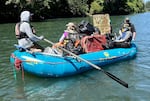
In this provided photo, Willamette Riverkeeper volunteers use rafts to move trash found along the Willamette River in Eugene in 2022.
Photo courtesy Willamette Riverkeeper
Since 2018, the nonprofit has been hosting volunteer trash cleanups in different parts of the river. The agency summarizes two years of reports on surface water pollution across the state.
The Willamette Riverkeeper collects 124 to 432 yards of trash annually (enough to fill approximately 50-173 truck beds), depending on the volume and scope of the cleanup event.
The Oregon DEQ determined that the data was sufficient to list sections of the Willamette River affected by pollution. This means local agencies within the boundaries of these rivers may face cleanup regulations in the future. DEQ proposes to list the section of the river between South Eugene and North Corvallis and the section of the Columbia River between Lake Oswego and the mouth of the Willamette River as damaged by aquatic debris.
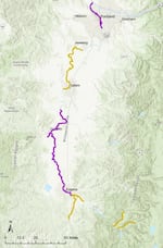
The Oregon Department of Environmental Quality is proposing to list a section of the Willamette River (highlighted in purple) as one affected by trash, which could trigger regulations requiring local jurisdictions to control this type of pollution. The sections highlighted in yellow require more data.
Map provided by Oregon DEQ
DEQ is required to submit water pollution data to the EPA every two years to comply with the Clean Water Act. Using this data, DEQ can recommend that EPA designate certain water bodies (such as streams, rivers, lakes, and oceans) as being harmed by certain types of pollution. If the EPA confirms that a water body is impaired, DEQ works with local jurisdictions to develop a total maximum daily load plan, known as a TMDL.
A TMDL is an extensive document that can take months or years to develop, and it typically includes contamination limits that local jurisdictions must meet over a period of time and who is responsible for meeting those parameters.
Water pollution reports in Oregon often focus on temperature pollution, such as wastewater treatment plants dumping water into streams that is too hot for fish to survive. DEQ officials say temperature probes make it easier to measure the type of contamination and easier to determine its exact source, such as a wastewater treatment plant. Some of the information DEQ relies on is submitted by other agencies and nonprofit organizations.
Trash is a little different. There is no single source of litter in rivers, lakes or oceans that officials can point to and mitigate, especially when it can be linked to broader social problems like poverty and homelessness. Therefore, only a few states have developed TMDLs for managing aquatic waste.
“With aquatic waste, we’re not 100 percent sure what it will look like,” said Lesley Merrick, DEQ water quality assessment manager. That will be part of the process, but the first step is identifying compromised waters.
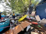
In this September 2021 photo provided by Willamette Riverkeeper, volunteers help remove trash from the upper Willamette River outside of Eugene.
Photo courtesy Willamette Riverkeeper
In addition to aquatic debris, DEQ added two types of water pollution to this year’s report: ocean acidification and hypoxia, and perfluorooctane sulfonate (PFOS), which is widely known as PFAS. A subset of permanent chemicals.
DEQ spokesperson Lauren Wirtis said these three particular problems are all very different and more difficult to address than water temperature contamination.It is not [from] A single entity, person or facility.
In addition to the Willamette River, DEQ recommends that Columbia Marsh, a 31-mile waterway between Fairview Lake and the Willamette River, be listed as PFOS-impaired under the Oregon Health Authority fish consumption advisory area.
DEQ is also proposing to list parts of the Oregon coast as damaged by ocean acidification and hypoxia, which are linked to climate change. The ocean absorbs carbon dioxide, increasing acidity and consuming oxygen. DEQ’s findings are based on three years of submitted data and the task force it assembled.
The agency proposes to list the shoreline from Falweather Point (south of Depoe Bay) to the Sirtecos River (north of Winchester Bay) as an acidification and hypoxia-impaired area. It also proposes that the coastline from the Columbia River to Lookout Point (southwest of Tillamook) be listed only for ocean acidification. If approved by the EPA, Oregon would be the first state to list seawater as damaged by ocean acidification.
#Oregon #limit #river #debris #ocean #acidification
Image Source : www.opb.org