- Late last year, a rare lake known as Lake Manley began to form in the Badwater Basin area of Death Valley, California.
- Death Valley National Park usually averages about 2 inches of rain per year, but 4.9 inches fell between late 2023 and early 2024, with even greater amounts falling in the surrounding mountains.
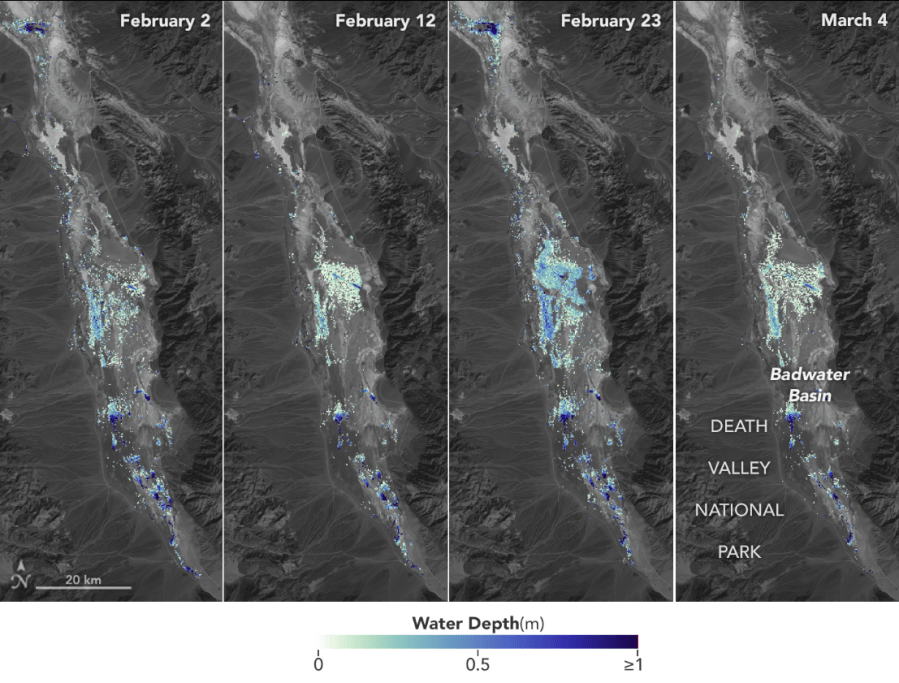
- A satellite discovered that the temporary lake was about 6 miles long, 3 miles wide and about 3 feet deep after a series of storms in early February.
SAN DIEGO (KSWB/KUSI) – The driest place in North America had a lake big enough to kayak last winter, and NASA has released data on how big the rare lake actually is.
Late last year, a rare lake known as Lake Manley began to form in the Badwater Basin area of Death Valley, California.
“You might think that without drainage to the ocean, Death Valley would always have a lake,” park ranger Abby Wines said in a February National Park Service press release said. “But this is an extremely rare event. Typically, the amount of water flowing in is much smaller than the evaporation rate.
The National Park Service reports that Death Valley National Park typically receives an average of about 2 inches of rainfall per year, but 4.9 inches fell between late 2023 and early 2024, with even greater rainfall in the surrounding mountains. Hurricane Hillary in August and atmospheric river storms in early February are the largest sources of rainfall in Death Valley.
NASA’s US-France Surface Water and Ocean Topography (SWOT) satellite, launched in December 2022 from Vandenberg Space Force Base in central California, found that the water depth in the temporary lake ranged from 3 feet to less than 1.5 feet. week.
The SWOT satellite also found that the temporary lake was about 6 miles long and 3 miles wide after a series of storms in early February.
To estimate the depth of the lake, NASA researchers used water level data collected by SWOT and subtracted the corresponding USGS land elevation information for the Badwater Basin.
“This is a really cool example of how SWOT can track how a unique lake system works,” said Tamlin Pavelsky, a hydrologist at the University of North Carolina at Chapel Hill and NASA’s SWOT freshwater science lead.
The shallow lake was briefly open to kayaking but closed to all boating after water levels dropped, the National Park Service said in an update Friday. Lake Manly has evaporated and is now only a few inches deep. It can only be reached via rugged salt and mud terrain, and there are no usable trails.
Boats were towed to Lake Manly and some of the surrounding salt flats were damaged.
Visitors to Death Valley and Lake Manley can walk in the water, but the National Park Service asks people not to walk in muddy areas where footprints can remain for years.
The National Park Service notes that wildflowers also bloom in Death Valley National Park, and the best places to see them are in Panamint Valley on CA-127 and NV-373 and east of Furnace Creek.
Copyright 2024 Nexstar Media Inc. All rights reserved. This material may not be published, broadcast, rewritten or redistributed.
#NASA #image #shows #big #Death #Valleys #rare #lake #winter
Image Source : thehill.com